AI-Powered Earth Observation & Geospatial Intelligence
Monitoring infrastructure, climate risks, and natural hazards from space.
Why Earth & Space Inc?
Scientific Leadership
Top-cited scientific expertise in Earth observation, remote sensing, geospatial analytics, and environmental monitoring.
Advanced Technology
AI, machine learning, satellite remote sensing, and spatiotemporal analytics for actionable intelligence.
Global Experience
Research projects, consulting activities, and scientific collaborations across four continents.
What We Do
Ground Deformation Monitoring
Satellite-based monitoring of subsidence, uplift, and infrastructure instability using advanced InSAR time-series analysis.
Geohazard Intelligence
Landslide susceptibility mapping, hazard assessment, and multi-hazard risk analytics for informed decision-making.
Climate & Environmental Monitoring
Monitoring environmental change, climate impacts, and groundwater interactions using Earth observation and AI.
Infrastructure Risk Analytics
Supporting railways, roads, industrial facilities, utilities, and municipalities with geospatial intelligence.
Featured Projects
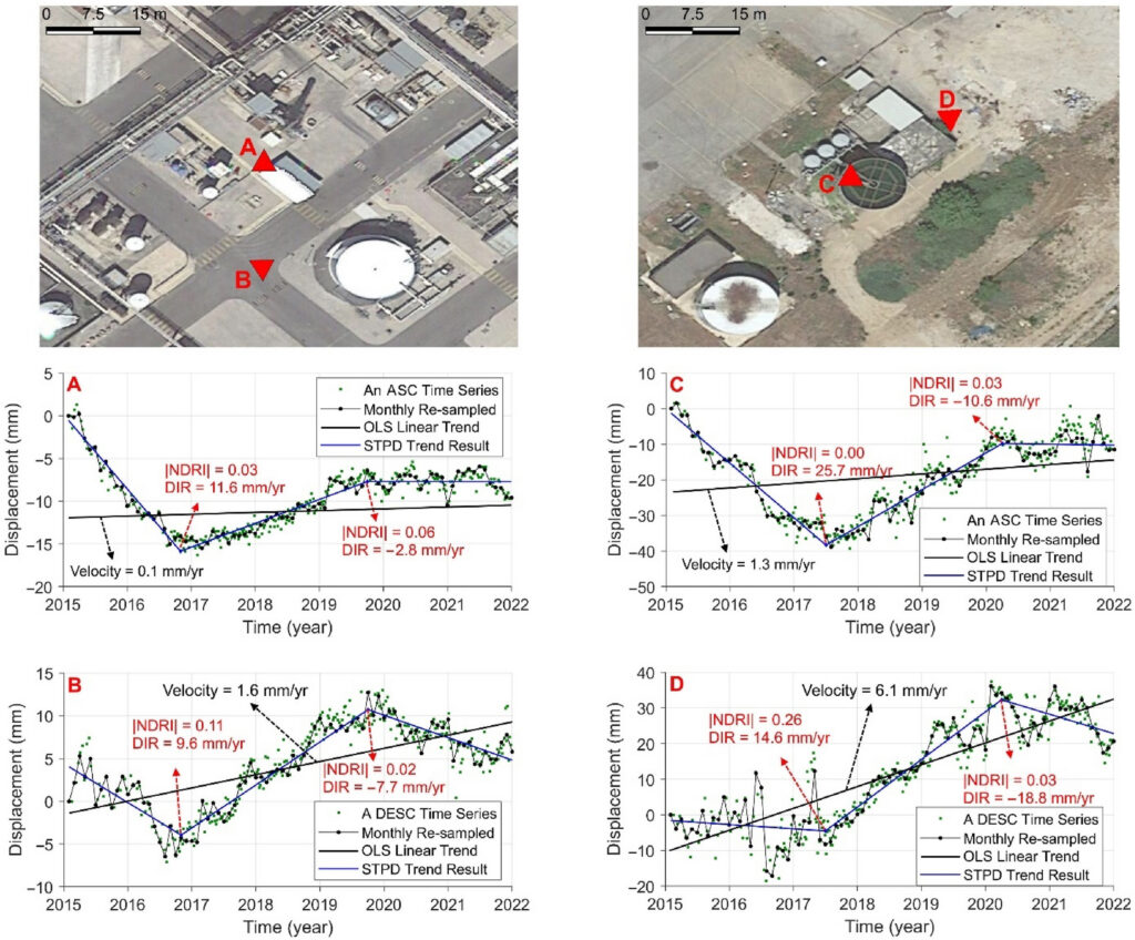
Monitoring Ground Deformation in Industrial Areas Using Satellite Time-Series Analysis
Earth & Space Inc. used satellite-based InSAR time-series analysis to monitor land subsidence and uplift in an industrial area within Italy’s Sacco River Valley. By analyzing long-term ground motion patterns, the project identified temporal changes associated with environmental and anthropogenic processes, supporting risk assessment and sustainable infrastructure management.
Ground subsidence and uplift detected using InSAR time-series analysis. Adapted from Ghaderpour et al. (2024)
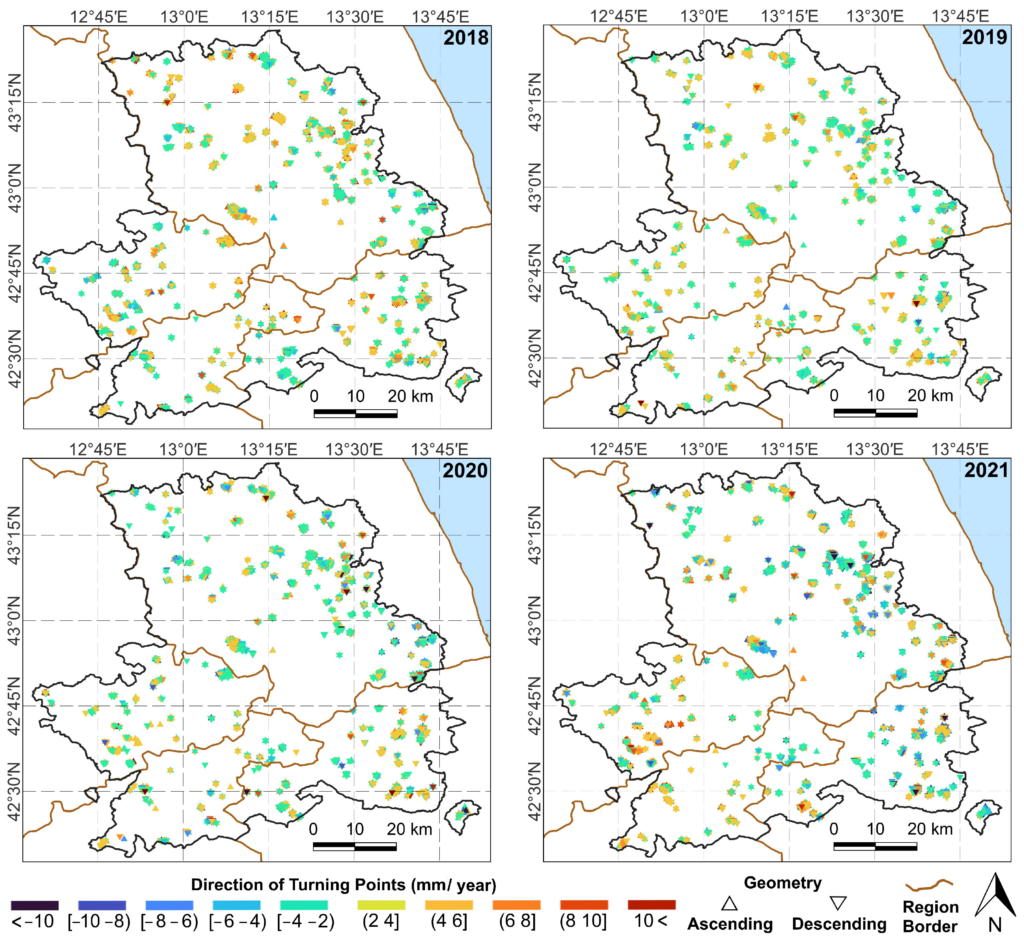
Monitoring Slow-Moving Landslides Using Satellite Time Series and Climate Data
Earth & Space Inc. combines satellite InSAR time-series analysis with precipitation data to identify the reactivation of slow-moving landslides and assess their relationship with rainfall. The approach supports hazard assessment, infrastructure protection, and risk-informed land management.
Spatial patterns of landslide reactivation derived from satellite InSAR time-series analysis in Central Italy. Adapted from Ghaderpour et al. (2024).
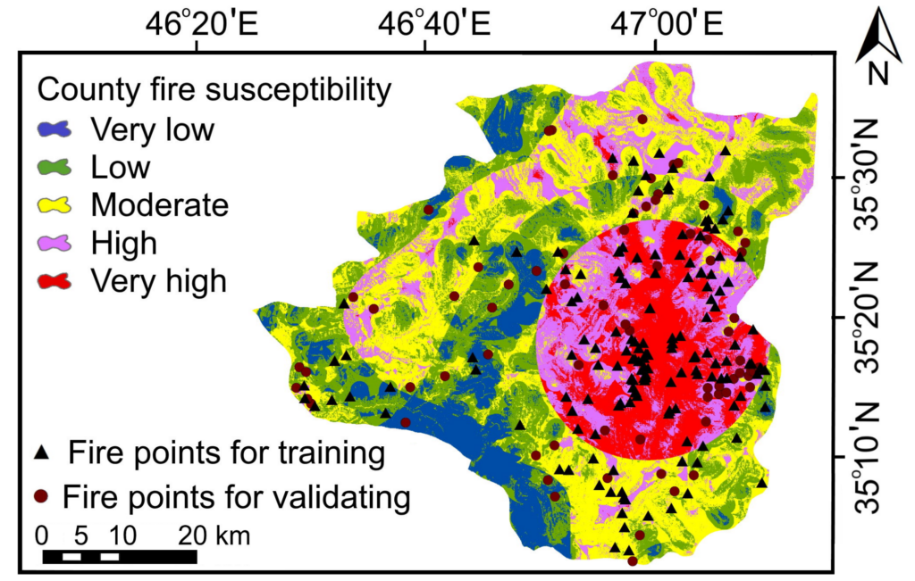
Wildfire Risk Forecasting Using Geospatial Analytics and AI
Earth & Space Inc. develops wildfire susceptibility and risk forecasting solutions by integrating satellite observations, environmental variables, and advanced statistical and machine learning models. The resulting risk maps support mitigation planning, resource allocation, and disaster preparedness.
Wildfire susceptibility map showing areas classified from very low to very high risk Wildfire susceptibility map, adapted from Salavati et al. (2022).

Agricultural Monitoring and Cropping Intensity Mapping Using AI and Earth Observation
Earth & Space Inc. develops advanced machine learning solutions for agricultural monitoring using satellite Earth observation data. By integrating Sentinel and Landsat time series within cloud-based geospatial platforms, the approach enables large-scale mapping and forecasting of cropping intensity to support agricultural planning, resource management, and food-security assessments.
Cropping intensity mapping and forecasting using satellite imagery and ensemble machine learning models. Adapted from Hosseini et al. (2024)
Industries We Serve
Infrastructure
Railways, roads, bridges, dams, and utilities.
Government & Public Agencies
Environmental monitoring, hazard assessment, and planning support.
Insurance & Risk Management
Climate intelligence and geohazard risk assessment.
Mining & Industry
Ground stability, environmental monitoring, and asset management.
Our Expertise
Earth Observation
Satellite-based monitoring and analysis of environmental and infrastructure dynamics.
InSAR & Ground Motion
Advanced monitoring of subsidence, uplift, landslides, and infrastructure stability.
Artificial Intelligence
Machine learning and predictive analytics for geospatial applications and Earth observation insights.
Climate Analytics
Assessment of climate impacts, environmental change, and ecosystem dynamics.
Geohazard Assessment
Risk evaluation and monitoring of landslides, subsidence, wildfires, and related hazards.
Geospatial Intelligence
Transforming Earth observation data into actionable insights for decision-makers.
Leadership & Scientific Network

Ebrahim Ghaderpour, Ph.D.
Founder and CEO of Earth & Space Inc. Dr. Ghaderpour specializes in Earth observation, geospatial analytics, remote sensing, artificial intelligence, and natural hazard monitoring. His work spans Global research, consulting, and scientific collaborations spanning North America, Europe, Asia, and Africa.
- Top-cited scientist in Earth observation and geospatial analytics
- 100+ peer-reviewed publications (Indexed in Scopus & Web of Science)
- International collaborations across four continents
- Expertise in geodesy, GNSS, AI, Earth observation, InSAR, climate analytics, and geohazard monitoring.
International Collaboration Network
Earth & Space Inc. collaborates with leading researchers, engineers, and practitioners from universities, research institutions, government agencies, and industry partners worldwide. This network enables the company to assemble multidisciplinary expertise tailored to each project’s scientific and operational requirements.
Let’s Work Together
At Earth & Space Inc., we are pleased to offer a free initial consultation to discuss your challenges, explore opportunities, and identify potential solutions tailored to your needs.
📩 Feel free to reach out and schedule your first consultation at no cost.